


Quinte Conservation is advising residents of the potential for river and lake levels to rise quickly. Weather conditions that have occurred during the holiday weekend (rainfall and warm temperatures) have started the second phase of the freshet, with some rivers moving towards flood levels.
Weather Situation: The Quinte area has received approximately 20 to 25 mm of rain over the past three days. Warm temperatures that started on Friday and continued throughout the weekend have initiated significant snowpack reductions north of Hwy 7.
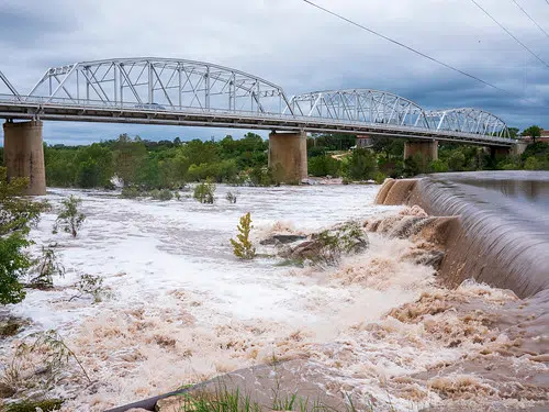
Watershed Conditions: Watershed creeks and rivers are currently swollen from recent rain and snowmelt. Recent weather conditions have caused water levels to rise quickly and generate nuisance flooding around small watercourses, urban areas, and ditches. Large river systems and inland lakes are responding quickly to additional water inputs. This winter has seen significant above-average snow accumulation. Currently, the snowpack throughout the watershed has been dramatically reduced, with a significant snowpack remaining in the wooded areas north of Hwy 7. Melting snow is associated with this strong second response and year’s freshet. Snowmelt in the northern regions is generating a quick response in lakes and rivers.
Ice conditions should be considered compromised due to significant rain and higher flows.
Risks: Prince Edward County: Swollen, small creeks and water course may rise to bankfull conditions and possibly inundate adjacent low-lying areas. Nuisance flooding is likely to persist for a few days. Watercourses may respond within a day before continuing to recede to seasonal levels.
Salmon and Napanee Watersheds: Major waterways are rising from rain and snowmelt experienced earlier in the month. Bankfull or near bankfull conditions could be expected within a few days. Serious flooding is not expected. Nuisance flooding is likely to occur around creeks and small watercourses.
Moira Watershed: Received rains have accelerated the melting of the remaining snowpack north of Hwy 7. Snowmelt and water release is dependent on air temperature and rainfall volumes. The Moira River and its northern tributaries (Black River, Skottamatta River and Moira north of Tweed) are responding with a second higher peak, with the potential to reach flood stage during the week. Higher flows may continue for several weeks into April.
Actions: Residents in flood prone or low-lying areas are reminded to take the necessary precautions to protect their property. Ensure sump pumps are in good working condition and have access to a portable backup generator and pump. Help reduce ponding by keeping ditches, culverts, and storm drains clear from obstructions.
FLOOD WATCH: This level notifies that the potential for flooding exists within specific watercourses and municipalities. Municipalities, emergency services and individual landowners in flood-prone areas should prepare.
This advisory will be in effect until (or updated before) Friday April 10, 2026
